Yesterday I had an email from a traveller looking for a comprehensive video of the Bay of Fundy to share with his friends back home. This is the first video that came to mind - I know it is still available to purchase on line....
Where The Bay Becomes The Sea (29:27 minutes)
Produced by the National Film Board of Canada. Still available to order on line, link to location on NFB website.
The richness, complexity and fragility of marine life unfold like a Persian carpet in this beautiful film. The bay of the title is the Bay of Fundy, and where it meets the sea a unique ecosystem has developed. The film traces the intricate interrelationships within the food chain, from tiny plankton, through birds and seals, and finally to whales and humans. More than just a visual feast, the film is a plea for careful management of our ocean resources. First telecast as part of the Nature of Things series.
Tuesday, October 31, 2006
Bay of Fundy video
Saturday, October 28, 2006
Fundy Ferry Saved!
 I was relieved to hear this morning that Bay Ferries will be continuing its ferry service across the Bay of Fundy. This is a great service that runs year round back and forth between Saint John, New Brunswick and Digby, Nova Scotia. Just two weeks ago I took this trip with a bunch of tourism folks from the region. There has actually been a ferry service operating across this part of the Bay of Fundy since the early 1800s...well before any significant roadways, let alone highways, were in place. Ridership aboard the current vessel, Princess of Acadia, has decreased somewhat over the past few years which is really too bad as it's an inexpensive way to cruise the bay and also cut down on the driving. If you're lucky you may even see a whale during the crossing! Many folks in the Digby and Saint John areas frequently walk aboard the ferry and venture over to the "other side" to visit friends and relatives.
(added ferry photo on Oct.31)
Tuesday, October 24, 2006
Bay of Fundy wins!

We won!
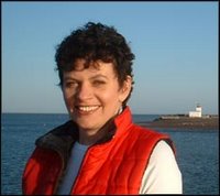
Last night at the Canadian national tourism conference in Jasper, Alberta, the Bay of Fundy Tourism Partnership was presented with a national award: the Parks Canada Award for Sustainable Tourism. I've been working with the Partnership for 9 years, so I got to go out to receive the award.
For about a year now we've been doing green business assessments for our member tourism operators: natural and historical attractions, accommodations and adventures. I'm really excited that all this hard work to make the Bay of Fundy a greener place is being recognized. Our partner for the implementing the eco-business program is Dalhousie University's Eco-efficiency Centre in Halifax, Nova Scotia. Here is a picture of me and Peggy (Manager of the Eco-efficiency Centre) in our fancy clothes accepting the award during the gala event.
Monday, October 23, 2006
Whales are following me!
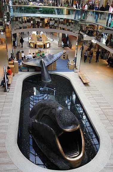
The last thing I expected to see in the world's largest mall was a whale! I knew that West Edmonton Mall had “something for everyone” but I was surprised and oddly amused to discover a life-sized (albeit a bit stout) baleen whale sculpture emerging out of concrete tub in mall floor. Interpretation about this gentle giant was unfortunately a bit scant. With the volume of people moving through West Ed, it struck me as an interesting opportunity to raise awareness of Canadian whales, their endangerment and their sensitive habitats. Or maybe the wishing coins that speckle its tub could be collected for whale research. If such awareness has to take place indoors at least it is better than live shows were captive whales and other sea mammals are “on show”…in my view.
Sunday, October 22, 2006
Chick outta water!
Bay of Fundy chick meets Alberta prairie city…I’ve just arrived in western Canada to attend a national tourism conference for the next few days. The Bay of Fundy Tourism Partnership project that I manage (my day job) has been short listed for a national award for sustainable tourism. Before heading out to the resort town of Jasper to attend the TIAC conference I’ve decided to visit the famous West Edmonton Mall...I'm told no visit to Edmonton is complete without it!
Wednesday, October 18, 2006
Do we really eat seaweed?
 I really wasn't joking in my last post, we do eat seaweed here in the Bay of Fundy...and not just because it's good for us. We actually like the taste! well, not everyone likes it, of course, but those who like it sure like it a lot. Sun-dried dulse is eaten as is or is ground into flakes or a powder (then dispensed from a shaker - see photo). I use dulse flakes wherever others might use salt. It's especially nice on poached or scrambled eggs, and also on baked potatoes. It can also be pan fried quickly (garlic butter optional) into tasty chips or baked in the oven covered with cheese then add salsa. When I was a kid we'd toss some on the back of the woodstove in the kitchen to crisp it up - try the microwave for a few seconds now. It can also be used in soups, chowders, sandwiches and salads, or added to bread/pizza dough.
Seaweed anyone?
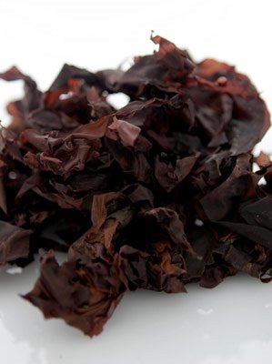
While we are on the topic of Bay of Fundy culinary delights, I feel compelled to share my love of one of our more unusual foods: dulse. Dulse is a natural sea vegetable (a fancy way of saying seaweed). It grows on the rocks at the low tide line in many areas of the Bay of Fundy. Dulse is best picked at the full and new moom tides (locals in my area call these "dulsing tides") each summer.
In most parts of Fundy it is hand picked then dried naturally, on beach rocks, by sea breezes under the summer sun. Dulse is sold year round in most corner stores, grocery stores and farm markets around the Bay of Fundy. I keep a small stash in the car and in my briefcase in case I get the munchies while traveling. Outside Atlantic Canada I often get funny looks from people while I chomp away on my seaweed snack!
Saturday, October 14, 2006
Spiced Beer Mussels
I promised to share more steamed mussel recipes after last month's posting of Mussels Panagea. The spices in this recipe are warm and appealing - perfect for the Bay of Fundy's cooling autumn temperatures.
Spiced Beer Mussels
12-ounce bottle of beer (not dark)
2 bay leaves
4 whole cloves
1 teaspoon coriander seeds
1 teaspoon mustard seeds
1/4 teaspoon cayenne, or to taste
1/2 teaspoon salt
2 lemon wedges
3 dozen mussels, scrubbed well in several changes of water with the beards scraped off
minced fresh parsley leaves for garnish
In a large pot, bring the beer to a boil with the bay leaves, the cloves, the coriander seeds, the mustard seeds, the cayenne, the salt, and the lemon wedges and boil the mixture, covered partially, for two minutes. Add the mussels, steam them, covered, over moderately high heat, stirring once or twice, for 4 to 7 minutes, or until they are opened, and discard any unopened ones. Serve the mussels sprinkled with the parsley.
Serves 6 as an appetizer, about 3 as a main. Don't forget the crusty bread to sop up the juices!
Monday, October 09, 2006
Thanksgiving swim in Fundy
 Well, it was my yellow lab, Belle, who was in the Bay of Fundy for a swim today - not me! The air temperature was 14 degrees C (about 57 F) and I doubt the water temperature was any warmer! By mid-afternoon the tide turned and started to go out exposing enough beach for a vigorous post-turkey walk for me and repeated swimming for Belle.
Sunday, October 08, 2006
Tide in...tide out!
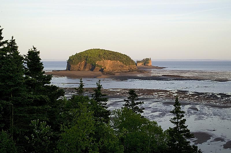
Around the Bay of Fundy there are hundreds of interesting places to "see the tides". However, visitors often mistakenly expect to capture Fundy's extreme tidal range during a single trip to the beach.
As any local can tell you, the tides are best seen at low tide and then again (6 hrs, 13 min) later at high tide...but at the same location. These photos are good example of the high/low extremes. But if you'd gone to the beach during high tide only you may not have been terribly impressed - just looks like any pretty cove. It is the difference between high and low that really blows your mind!
These pics were taken by U.S. travel writer, David Rosenthal, when I hosted David and Donna (also a travel writer) here in Parrsboro, Nova Scotia, this summer. Thanks to David for permission to post 'em!
Wednesday, October 04, 2006
"Friendly" Whales?
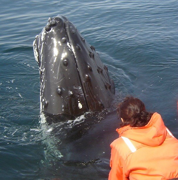 Just received this note & photo from Bay of Fundy whale watch operator, Tom Goodwin:
This season we had a few very interesting experiences with different humpback whales. 'Who's watching whom?' is the most relevant question. But also, is this good for the whales? ... Are they becoming too 'domesticated'?... is that bad or dangerous for the whales?... is our presence interfering with their normal position in their environment? .... or is it all part of 'evolution'? We whale watch operators are a conscientious lot and we like to think our activities watching whales do NOT
interfere with their behaviour, but when the whales express an interest in us, is that an interference? Hmmmmm
Learn more about Tom and his whale watching experience at Ocean Exploration "Zodiac" Whale Adventures, Tiverton, Nova Scotia
Sunday, October 01, 2006
More Fall Colours
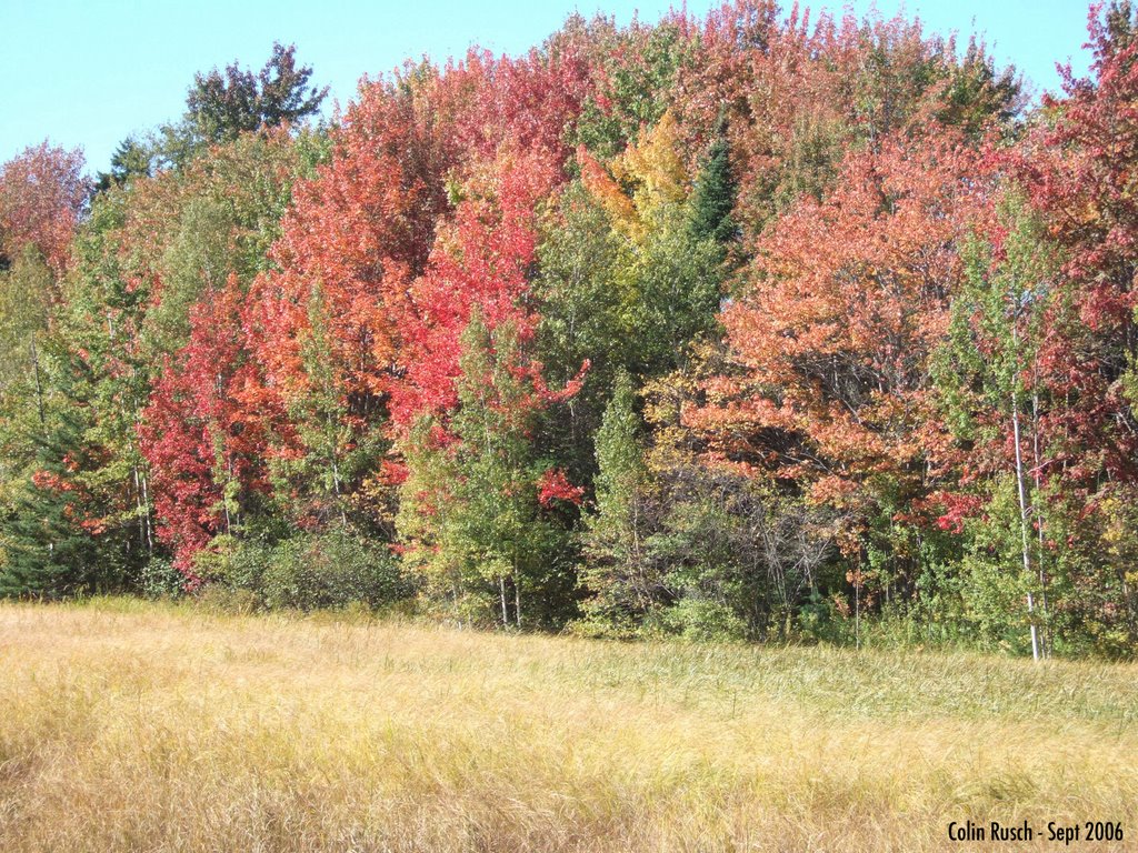 The Bay of Fundy's coastal marshes with their twice daily salt bath from the tides also show off variations in fall colours. I was around the bay this week with a tourism colleague from Toronto, Colin Rusch. Here's a photo he snapped enroute.
This is a tidal river/salt marsh near Hillsborough on the New Brunswick side of the bay. Check out the golden sea grasses glowing beautifully below the bright maples.
Friday, September 29, 2006
Fundy's Fall Colours
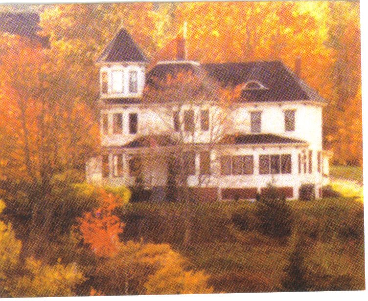
I think that the Bay of Fundy shores offer some of the best places on Canada's east coast to see the autumn colours. Here, it's not only hardwood trees, like maples, that change colour in the fall. The salt marshes flanking Fundy's tidal rivers are alight with golden sea grasses and our rolling blueberry fields are crimson (a change from bright blue berries and green leaves when harvested about a month ago).
Here is a glorious photo of my captain's house ablaze in autumn colours...no special effects here!
Tuesday, September 26, 2006
Cowboy Question #3
Q3: Why do Fundy's waves come inward toward the shore even when the tide is going out?
Even though the tidal current is actually drawing water away from the shore as the tide recedes, it's true, the waves continue to come toward the shore. Sets of waves, of course, move further and further off shore as the tide backs out.
This happens because waves are actually caused by wind not by the tide itself. Strong winds create rough waters, and light winds cause the water to be more calm. A lot of people who have never seen the tides, like my friends from western Canada, expect that the waves themselves turn around to take the water out!
A person can get a bit cross-eyed trying to figure this out!!
Sunday, September 24, 2006
Cowboy Question #2
Q2. When the tide is high in the Bay of Fundy is it low on the other side of the world?
A logical question from our prairie visitors!
Actually it is more likely to be high on the other side of the world and low a quarter way round in either direction. This is because the moon produces two tidal bulges somewhere on the Earth through the effects of gravitational attraction. The height of these tidal bulges is controlled by the moon's gravitational force and the Earth's gravity pulling the water back toward the Earth.
At the location on the Earth closest to the moon, seawater is drawn toward the moon because of the greater strength of gravitational attraction. On the opposite side of the Earth, another tidal bulge is produced away from the moon. However, this bulge is due to the fact that at this point on the Earth the force of the moon's gravity is at its weakest.
Considering this information, any given point on the Earth's surface should experience two high tides and two low tides during each tidal period.
Tuesday, September 19, 2006
Cowboy Question #1
I had rancher friends visiting from western Canada (Alberta) this past week. They'd never been to the Bay of Fundy before and sure had some interesting questions about the tides. I like to think I'm pretty well versed in matters tidal but a couple of questions caught me by surprise. I'll research and answer these questions in my next few postings...
Q1. Why are the tides so much higher in this funnel shaped bay when there are lots of other funnel shaped bays on various coasts around the world?
The high tides of the Bay of Fundy have less to do with the fact that the bay is funnel shaped and more to do with two other factors:
a) the bottom topography and depth of the bay, and
b) the unlikely fact that the bay's natural resonance coincides almost perfectly in "wave length" with that of the Atlantic ocean.
So, let me explain...
The mouth of the Bay of Fundy is 100 km (62 miles) wide and between 120 and 215 meters (400-700 feet) deep. The bay gradually narrows and becomes more shallow until it splits to form Chignecto Bay and the Minas Basin. The distance across the bay in either of these two smaller bays is only a few km (miles) and the depth at low tide about 14 meters (45 feet).
The gradual tapering and shallowing constricts the tidal flow, causes the water to rise from an average of one meter (3 feet) found elsewhere in other tides to the 16-meter (52 feet) tidal range found at the head of the Bay of Fundy.
The second factor contributing to the highest tides....
Every basin of water has its own natural rhythm and at 290 km (180 miles) long, the time it takes for the tide to flood the length of Bay of Fundy is nearly identical to the time it takes for the tide to come in from the adjoining Gulf of Maine.
This resonance - the meshing of these two rhythms - means that the tidal range is amplified. Called the "Seiche Effect", this amplification is frequently compared to the wave action produced by a child sloshing water back and forth in a bathtub, each wave higher than the one previous. It is this comparison which led to the Bay of Fundy being called 'the world's largest bathtub'.
When the tide is fully out here in our harbour, it really does look like somebody pulled the plug on the tub!
Sunday, September 17, 2006
What About Mackerel?
Well, since I profiled herring, I thought it only fair to give mackerel its due...
Fundy's mackerel (Northern Atlantic mackerel) are found on both sides of the north Atlantic. On this side, mackerel overwinters along the edge of the continental shelf. In spring, Atlantic mackerel move inshore and northward to spawn and then, in summer, move further northward into the Gulf of Maine and thus the Bay of Fundy.
Here in town, the locals know by word-of-mouth when the mackeral are "running" - that is, coming in on the incoming tide and up tidal rivers.
Mackerel can live up to 17 years and grow to a maximum of 61 cm (2 feet).
Atlantic mackerel are sought after for food either cooked or as sashimi (kind of like sushi). Mackerel consists mostly of red meat and has a stronger taste than its cousin, the tuna. Atlantic mackerel is extremely high in vitamin B12 and very high in omega 3, containing nearly twice as much per unit weight as does salmon. Unlike King mackerel and Spanish mackerel, Northern Atlantic mackerel are very low in mercury, and can be eaten at least twice a week according to EPA guidelines.
Mackerel does spoil quickly though - it is best eaten on the day of capture, unless cured. For this reason, mackerel is the only fish traditionally sold on a Sunday in London, England. (It makes me think of the market call "mackerel, fresh, mac-ker-el!").
Did you know that both herring and mackerel are rated by Oceans Alive as an eco-best fish? These folks rate all seafood to help consumers determine whether or not they are making an environmentally responsible choice when buying and ordering fish.
Thursday, September 14, 2006
Weir images

Well, I'd better dust off my camera and get down to the local fish weir to take some pics! I've not been able to track down any images showing the weirs that are dry at low tide (like the one near where I live).
In the meantime, here 's a photo of weir at Grand Manan. This kind of weir is 'fished' from a boat as mentioned in my previous posting.
Also, here's a neat animation of fish swimming into a weir and then around in a figure eight pattern waiting to be caught!
http://phocoena.org/newfeatures/hprp.html
And this is a site that features weir photos by Jorgen Klausen. He's taken some absolutely stunning photos of weirs. Take a look!
http://www.jorgenklausen.com/colour/bay_of_fundy_weirs/bay_of_fundy_weirs.htm
Sunday, September 10, 2006
A Bit More About Herring
Atlantic herring are called brit for the first year, sardines if under 17.5cm (7"), sea herring (or bloater or roe herring) if larger than 23cm (9"). Full grown herring may reach lengths of 43cm (14").
Herring, in all its various forms, is commonly eaten by people around the Bay of Fundy in the following ways:
Eaten Fresh - steamed, pan fried, baked, BBQ'd
Smoked as Kippers - the head and guts removed and the herring are split down the back into a butterfly fillet, then lightly salted and smoked while pinned to a board for a couple of days. These fillets need refrigeration and are often eaten for breakfast.
Smoked as Bloaters - developed before refrigeration, the fish are heavily salted and then smoked - the process involves stringing herring on sticks like beads, hanging them in smoke houses until finished, taking them to boning sheds to have skin and bones removed and packing in wooden boxes before shipping. The fillets are sometimes called "Digby Chicks". They are eaten as is or soaked and then poached in milk.
Sardines - When herring are small they are called sardines, not to be confused with species of sardines (Sardinia sp. including pilchards) found in the Mediterranean and western Europe. Small sardine herring, with heads and tails removed, are packed into cans with soya oil, spring water or other sauces such as tomato, mustard, etc. Although it is possible to automate the procedure, many sardines are still packed by hand. Once the lid is applied the cans go into a retort oven which cooks the fish in the tin.
Pickled - a tasty treat of smoked or fresh herring chunks, pickling spices, onions, sugar and vinegar.
Pickled herring (known as "Solomon Gundy") is commonly found in Fundy area grocery stores as are kippers, and, of course, Connors Brothers canned herring with their various sauces. I remember my dad taking a couple of cans of herring with his lunch every day in case he needed a snack...and to think potato chips were invented by then and he chose herring instead!
Herring eggs are also used as caviar or in sushi - my personal favourite but not as commonly found out here in rural areas. No wonder there is something about sushi, with its seaweed, fish and roe, that tasted awfully familiar when I first ate it!
In addition to being used as bait for lobster traps, one other non-food use for herring involves the scales....
herring scales are collected and transformed into "Pearl Essence" (used in nail polish, lip gloss, pearly buttons, automotive paint, etc.)
(this information about herring exerpted from the Grand Manan Island website)
Weir Fishing on the Bay
Early this morning I heard my neighbour rumble by in his pickup truck and, since the tide was a couple of hours from being fully out, I figured he was heading down to the beach to check his fish weir for herring, mackeral and assorted other fish. Mussels are certainly not the only seafood that we locals eat that comes from the Bay! Although weir-fishing appears to be a very low-tech (dare I say "biblical") way of catching fish, it is extremely effective. Last year, in a single tide, my neighbour told me that he caught 42 tonnes of fish! Chances are that if you live in North America and eat canned sardines (which are actually herring before they get bigger), those fish probably came from the Bay of Fundy.
People have been weir fishing in the Bay of Fundy for hundreds of years. When European settlers arrived in my area in the 1770s, they would have found our first nations (Passamaquody and Mik'maq) peoples already using brush weirs to catch fish.
So....what is a Weir?
A weir is heart or kidney shaped structure built from long poles and netting that acts to catch and concentrate fish. Fish swimming along the shore first encounter a net running perpendicular to the shoreline and alter their course to swim along it. This "fence" directs the fish into the mouth of the weir where they swim across the weir and encounter the back twine. Once inside the weir, the fish swim in a figure eight pattern always being directed away from the mouth by the curve of the netting (or twine).
Where I live, in the upper part of the Bay, the tide goes out so far that the weirmen actually walk out on the ocean floor a couple of hours before low tide to tend their weirs. There is still a few feet of water in the weir so they move around inside the net scooping up live fish with their hand nets. Since it's low tide they can drive their trucks out onto the beach of the intertidal zone and toss the fish into the fish boxes to take them fresh to market. If you're on the beach at the right moment you can try your hand at gathering fish out of the weir (it's not as easy as it looks) or, at the very least, you can enoy buying fresh fish right out of the water!!
The tricky bit about weir fishing is that the weir needs to be checked with every tide - otherwise the nets risk being damaged by pesky seagulls. It takes 6 hours and 13 minutes for the tide in the Bay of Fundy to go from high to low. Therefore, it's about 12 and 26 minutes from one low tide to the next low tide (or one high tide to the next high tide).
For example if the tide was:
high at 8 am this morning,
it would be low at 2:13 pm,
then high again at about 8:26 pm,
and low again at 2:45 am tomorrow
then high again just before 9 am tomorrow, etc.
So the tide times effectively move ahead about an hour every day. If the tide is high at noon today, it will be high around 1 pm tomorrow. This makes for some fairly inconvenient times for several days of the month when my neighbour has to go out to check his weir in the middle of the night!
In other parts of the Bay of Fundy, such as off Grand Manan Island, the weirs are fished with seining nets from floating boats because the tide doesn't go out far enough to expose the whole weir. The seine boat crew manoeuvers around the inside of the weir, deploying the net into the water. Once completely around, the bottom of the seine can be drawn tight (or pursed). The herring are then literally brought to the surface in the seine by bringing the seine back on board the seine boat.
I'll see if I can track down some drawings or pictures of the two types of related Bay of Fundy weirs.
Friday, September 08, 2006
Recipe for Mussels Panagea
Here’s one of my favourite mussel recipes. The Bay of Fundy was actually connected to northern Africa before the world’s giant all-in-one continent, Panagea, divided (240 million years ago) into the various continents we know today. Maybe that’s why the Morrocan flavours of this mussel recipe seem so familiar to me...yum yum!
1 med. onion, coarsely chopped
2 garlic cloves, sliced
1 ¼ tsp ground cumin
1 tsp paprika (hot paprika powder if you can get it)
1 Tbsp grated fresh ginger (or powdered, if you don’t like it spicy)
1/2 tsp ground cinnamon
1/8 tsp cayenne
3 Tbsp olive oil
1 Tbsp cider vinegar
1 (15 oz) can chickpeas, drained and rinsed
1 dollop of honey
1 (28 oz) can plum tomatoes, drain and reserve juice, chop
3 lbs mussels, scrubbed under fresh water with beards removed
2 Tbsp fresh parsley, chopped
Cook onion, garlic, and spices in the olive oil in a 6-quart heavy pot over medium heat. Cook and stir about 5 minutes until onion is soft and slightly clear.
Stir in the vinegar and simmer for 1 minute.
Add the chickpeas, honey, and tomatoes with their juice.
Increase the heat to medium and gently simmer, uncovered, stirring occasionally until slightly thickened, about 15 minutes.
Add the mussels and lower heat to a simmer.
Cover tightly with lid and cook until mussels just open wide, about 3-6 minute. Throw out any mussels that remain unopened after 6 min.
Stir in parsley and serve in shallow bowls with a nice crusty bread. Serves 4.
Thursday, September 07, 2006
Very cool Fundy 3D map
OK this is really neat. While I was looking for Fundy maps I came across a really cool map on the Gulf of Maine Aquarium's website. It's an interactive, "pop up" style map that shows the depth and undersea topography of the Bay of Fundy within the Gulf of Maine watershed. It's clear that the Bay is part of the vast inland see known as the Gulf of Maine.
Also here's an excellent description about where the Bay of Fundy is located (nicely said by the folks at the Aquarium):
"Look as far eastward as you can on a map of America. Trace your finger along the coast, over Long Island, past Rhode Island, then slide along the edge of a neatly cupped body of water called the Gulf of Maine. Apparently open to the Atlantic, a discerning eye (and a bathymetric chart!) will note that the Gulf of Maine is a semi-enclosed sea, bordered on three sides by Massachusetts, New Hampshire, Maine, New Brunswick, and Nova Scotia, and neatly boxed in on the east by two underwater banks. Though a part of the North Atlantic from the surface, the Gulf of Maine is really a sea nestled beside an ocean....
...traveling up the Maine coast, rocky headlands and granitic islands offer the drama and beauty many associate with the rugged Northeast. Farther east, in New Brunswick and Nova Scotia, the landscapes show the effect of the world's highest tides. In the Bay of Fundy, which separates Nova Scotia and New Brunswick, the tide may rise by as much as 54 feet (17 m) in height. By contrast, tides in Boston Harbor will vary by just 9.5 feet (3 m) from high to low tide. At low tide an array of sandbars, vast mud flats, and even ancient forests drowned by the rise of the sea are exposed."
Hey I appreciate living here today even more than I did yesterday!
September 8 -- Fixed hyperlink.
Monday, September 04, 2006
Where is the Bay of Fundy?

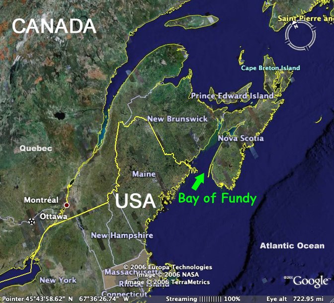
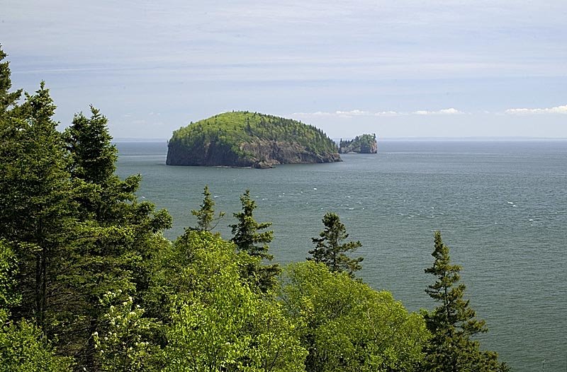
The Bay of Fundy is a 270km (170 mile long) ocean bay on the east coast of Canada between the provinces of New Brunswick and Nova Scotia. But if you wanted to kayak all around the bay staying close to the coast you'd find about 1,705 km (1050 mi) of sculpted cliffs, tidal rivers, basalt headlands and smaller bays to explore. Well, the kayaking could be tricky....your kayak trip could become a portage walk on the ocean floor when the tide goes out!!
I grabbed a few images off Google Earth so you can get a sense of where we are - I'm crazy about maps so I'll add more maps and aerials as I discover them!
Saturday, September 02, 2006
Welcome to my blog!
I've lived on the Bay of Fundy all my life. I heard about this new blogging thing from my more tech-savvy kids and I thought it was a great opportunity to share the wonderful experience of living and working beside the most extreme tides in the world. I figure 100 billion tonnes of sea water flowing in and out of our Bay twice a day deserves its own blog! (By the way, that's more than the combined flow of all the freshwater rivers in the world)
Check back soon - hopefully I'll track down a good map to show you where I'm posting from.